Lake Tahoe via Gold Country (San Francisco to Lake Tahoe) Beach Bliss to Alpine Adventure
Distance & Time: ~220 miles to South Lake Tahoe (approximately 4–5 hours driving). North Lake Tahoe (around Truckee or Tahoe City) is similar in distance. A weekend trip is ideal. You can go up one route and return another to make a loop and see more sights.
Route: From San Francisco, take I-80 East through Sacramento (the state capital, ~90 miles from SF). This route leads to North Lake Tahoe. If your destination is South Lake Tahoe, you can switch in Sacramento to US-50 East, which goes through Placerville and over Echo Summit down to South Lake Tahoe. Both I-80 and US-50 are scenic in different ways one goes by historic Gold Rush towns (US-50), the other by Donner Pass and Truckee (I-80). You could even take I-80 there and US-50 back (or vice versa) to circle the lake on your return. Either way, you’ll climb from sea level to over 7,000 feet through the Sierra Nevada mountains before descending to the lake shore.
Highlights: There’s plenty to see on the way to Tahoe before you even reach the lake. In Sacramento, if you have time, explore Old Sacramento a 1800s riverfront historic district with wooden sidewalks, wagon wheels, and the excellent California State Railroad Museum. Continuing east, US-50 winds into California’s Gold Country. You’ll pass through towns like Placerville (once infamously nicknamed “Hangtown” in Gold Rush days for its rough justice) today it’s a charming town with antique shops and cafés, plus nearby apple orchards. In autumn, the Apple Hill area around Camino bursts with fall colors, apple picking, and fresh-baked pies (a delicious detour if timing allows).
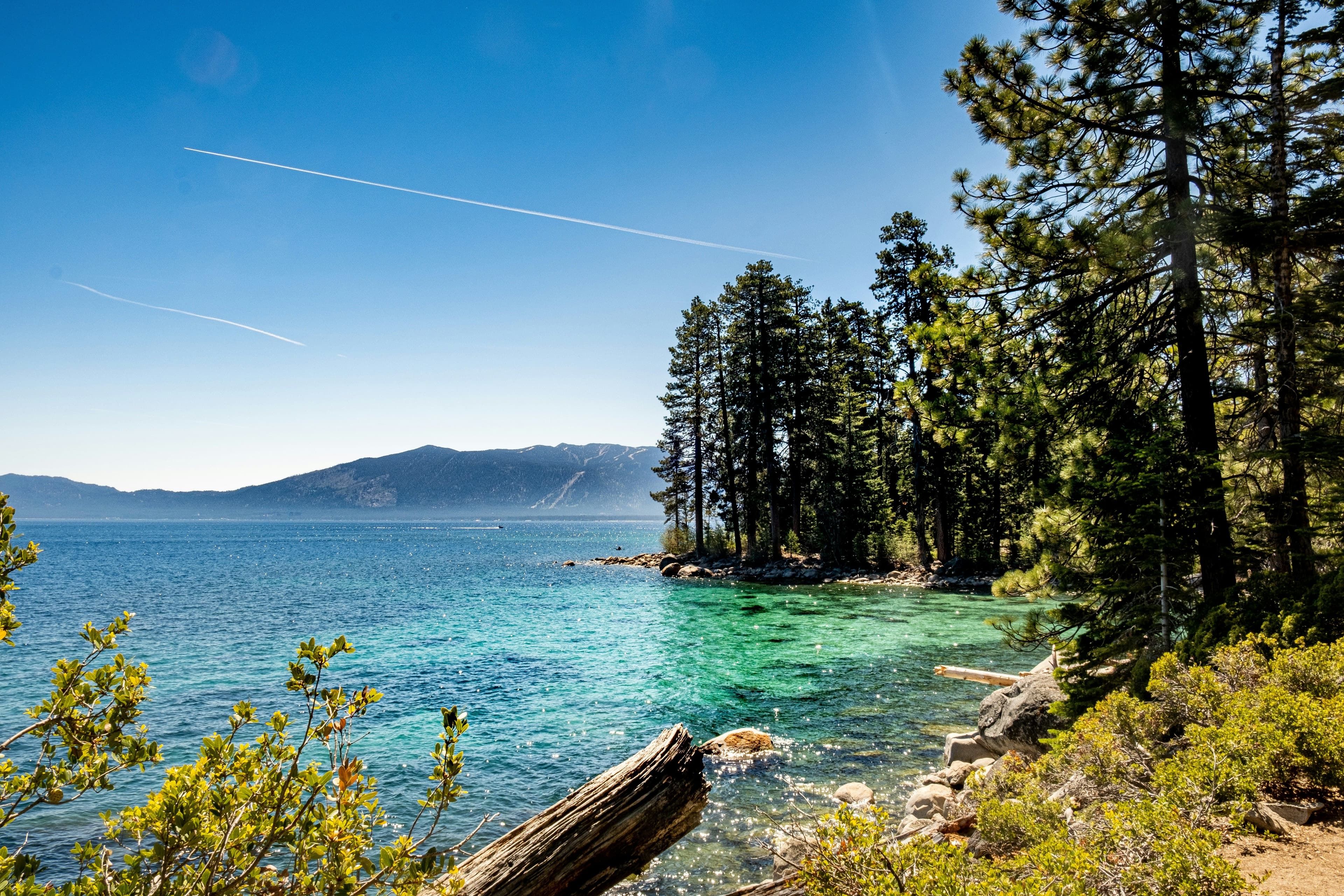
As you approach Tahoe on US-50, the environment changes from oak foothills to alpine pine forests. The road climbs over Echo Summit (7,382′); at the summit, you’ll suddenly get a breathtaking view of Lake Tahoe as you begin the descent. The reveal of Tahoe’s brilliant blue water framed by granite peaks is unforgettable. Lake Tahoe, straddling the California–Nevada border at over 6,200 feet elevation, is one of the largest alpine lakes in the world (and the largest in North America). In summer, the lake’s clarity and color are astounding you can swim, kayak, or simply relax on beaches like Sand Harbor, Kings Beach, or Pope Beach. A must-see spot is Emerald Bay State Park on the southwest shore: from the roadside vista point you gaze down at Emerald Bay’s teal waters and Fannette Island, Tahoe’s only island (it’s a postcard come to life). Hiking down to Vikingsholm castle (a historic mansion on the bay) is another option if time permits. For a panoramic drive, continue around the lake’s circumference (~72 miles) you’ll encounter panoramic overlooks, charming towns like Tahoe City and Incline Village, and the dramatic eastern shore with its rocky coves.
In winter, Tahoe transforms into a snowy playground. Major ski resorts dot the region Heavenly (in South Lake Tahoe), Palisades Tahoe and Northstar (north shore), among others. Even if you’re not skiing, the snow-clad scenery is gorgeous and you can find sledding, snowshoeing, or simply enjoy a cozy lodge with a view. The drive up I-80 via Donner Pass is historically interesting (near Donner Lake there’s a museum about the ill-fated Donner Party) and offers its own mountain vistas. And no matter the season, Tahoe’s majestic scenery towering pines, granite peaks, and that vivid blue lake will leave an impression. This road trip truly showcases the diversity of California, taking you from Bay Area beaches to alpine lakes all in a day’s drive.
Tips:
- Prepare for variable weather: Tahoe’s Mountain weather can be very different from San Francisco’s. In winter, snow is common in the Sierra. Both I-80 (over Donner Pass) and US-50 (over Echo Summit) are well-maintained highways but can close temporarily during heavy storms or require chains/traction tires. Check road conditions if snow is forecast and carry tire chains just in case don’t attempt mountain passes in winter storms without proper equipment. In summer, Tahoe is extremely popular on weekends, which means heavy traffic leaving the Bay Area Friday afternoons or coming back Sunday. Plan to leave early in the day to beat the worst congestion (and to have more time by the lake).
- Don’t rush the drive: There are plenty of worthwhile stops along the way. For instance, stretch your legs in Sacramento (perhaps lunch in Old Sac), or in Placerville to browse a bit of Gold Rush history. If you have an extra hour in fall, a quick detour through Apple Hill off US-50 is fun for cider and pie. Nearing Tahoe, Emerald Bay is a must-stop for photos it’s one of the most photographed views of the lake, with good reason. Also consider taking the scenic route around Lake Tahoe at least partly, instead of driving straight to one town. The western shore drive past Emerald Bay, or the northeastern shore by Incline Village, offer incredible viewpoints of the lake.
- Drive the lake loop if time allows: A full circumnavigation of Lake Tahoe is about 72 miles. If you can fit it in (or at least do a portion), it’s well worth it. The south/west side gives you Emerald Bay and views of the Desolation Wilderness peaks; the north shore has cute communities like Kings Beach; the east shore (in Nevada) has hidden gems like Sand Harbor and Spooner Lake with brilliant turquoise shallows against white boulders. Even a partial loop will enhance your Tahoe experience beyond just one town.
- Altitude considerations: Lake Tahoe sits over 6,200 feet above sea level, and the surrounding activities can take you above 7,000 feet. At these elevations, the sun’s UV strength is stronger and the air is dryer. Wear sunscreen (even in winter on the snow) and stay hydrated by drinking water regularly. If you’re sensitive to altitude, take it easy on your first day mild shortness of breath or fatigue can happen until you adjust. Also, temperatures can swing widely; even in summer, nights get cool. Bring layers so you’re comfortable from the strong midday sun to the brisk mountain evening.
- Enjoy the journey: This trip offers a little of everything urban history, Gold Country lore, and stunning alpine scenery. Make sure to soak it all in. Whether you’re boating on the crystal-clear lake in July or marveling at snow-flurries over the passes in January, you’ll be experiencing a side of California far removed from the city. On the drive back to San Francisco, you’ll descend from the Sierra Nevada and likely be treated to a beautiful view of the Central Valley or even the skyline of the city as you approach a reminder of how much ground (and how many environments) you’ve covered in just a few days. Safe travels and enjoy the adventure!
Our Most Popular Vehicles